- Home
- Attractions
- All Attractions
- ATTRACTIONS PROFILES
.jpg)
Soysambu Conservancy
If you’ve never seen it, the Great Rift Valley in Kenya is a must! It is one of the geologic wonders of the world. Standing on the ground where our ancestors walked this earth for the first time, or climbing the dramatic volcanic cones you can see the powerful geologic activity where the earth is pulling apart…rifting…a feature on the face of the earth that can be seen from the moon. Species of animals have lived in harmony with nature for eons here.
This far south there was no ice age, Soysambu is 30 miles south of the equator at an elevation of 6000 feet. As you stand on Soysambu and look east you can see the Aberdare Mountains, turn around and there is the Mau escarpment beyond which lies the magnificent Masai Mara. Soysambu is located just 2 1/2 hours from Nairobi off the main Nairobi to Nakuru road, Soysambu is the perfect location for an easy getaway from the hectic Nairobi city life or if you are traveling from afar, spend a few days soaking up the beauty and history of the area while enjoying gamedrives, walks and other activities offered through the lodges and camps on Soysambu.
-
Birding Site
-
Wildlife Conservancy
.jpg)
Taita Hills Wildlife Sanctuary
Taita Hills Wildlife Sanctuary is a privately owned wildlife sanctuary in Kenya. It is located in Taita-Taveta County approximately 220 kilometers from Mombasa. The sanctuary covers an area of 28,000 acres (110 km2), and is adjacent to Tsavo West National Park and the LUMO Community Wildlife Sanctuary. It hosts cape buffalo, African bush elephant, African leopard, Masai lion, Tanzanian cheetah, Masai giraffe, zebra, hartebeest, impala, waterbuck, Thomson's gazelle, lesser kudu, dik-dik, and other smaller animals, including a great diversity of birdlife.
Taita Hills Wildlife Sanctuary was established in 1972 by Hilton International. The sanctuary has two lodges, the Sarova Salt Lick Game Lodge and the Sarova Taita Hills Game Lodge, both operated by Sarova Hotels.
-
Animal Sanctuary
-
Birding Site
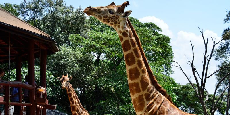
Giraffe Centre
The centre has been ostensibly set up as a breeding centre for the endangered Rothschild giraffe, but now operates conservation/education programs for Kenyan school children. There is good information on giraffes available here, and an elevated feeding platform where visitors meet the resident giraffes face to face.
The Giraffe Centre is the creation of the African Fund for Endangered Wildlife (A.F.E.W. Kenya), a Kenyan non-profit organisation. Our main purpose is to educate Kenyan school children and youth on their country’s wildlife and environment, as well as give local and international visitors an opportunity to come into close contact with the world’s tallest species, the giraffe.
WHAT TO DO AT THE GIRAFFE CENTRE
Not sure what to do at our centre? Or maybe you would like to plan your itinerary for the day? There is a notice board at the right of the payment booth, where the whole of our centre is mapped out for you. Getting your bearings is a good start to an enjoyable visit.
Find some important information on the notice board for your consideration too. Aside from the notices that come and go, there is a list of recommendations on how to feed the giraffe. Read these and you are good to go.
You don’t have to internalise everything. Our Educators are on hand to guide you, if you so wish. You can identify them in their khaki outfits. They will be quick to approach you, but if it is a busy day - as it often is— don’t hesitate to seek them out and ask for help.
BROWSING AREA
The awe our tall friends elicits will lead you right here. An Educator will hand you some food pellets. Made of corn, wheat, grass and molasses, they are what you will feed them as you get up close. To get even closer, go up to the Feeding Platform. Don’t leave without getting a kiss!
INFORMATION CENTRE
Attend a short lecture on the giraffe to learn how and why we are taking care of this endangered animal. Leave with a whole lot more about wildlife in Kenya. We have artwork for sale on display. Made by students, the proceeds go towards supporting Ecology Trips for the underprivileged.
NATURE SANCTUARY
Our Nature Trail is available to you at no extra cost.
Take a stroll, or hike if you’re up to it, in our serene 1.5-kilometre nature trail and see how many species of bird you can spot - the record in one stroll is 60! Watch out for smaller animals such as dikdik and squirrel.
The trail goes down to the snaking Gogo River. If you want to see its source, the Ngong Hills, go up to the View Point. The view is breathtaking.
An alternate route back to the centre will pass you by the Warthog Den. Be careful that one doesn’t come springing after you from the deep black holes!
TEA HOUSE
Wind down your visit with refreshments, people and giraffe watching and some mingling here.
THE GIFT SHOP
Pop into the Daisy Zoovenir Shop for some keepsakes on your way out. We must warn you, people have spent hours in there! Remember, the Giraffe Centre derives 90 percent of its funds from the entrance fee collected and sales in the gift shop and Teahouse. Shop till you drop, it’s for a cause.
We hope you enjoyed your visit, we certainly loved having you!
-
Animal Sanctuary
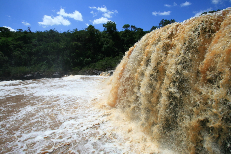
Chania falls
This is another water fall within the proximity of the capital city of Nairobi. It provides a breath taking and scenic attraction of the falls as well as the surrounding. Apart from its suitability as a birding site, Chania Falls sets up a great picnic, camping and retreat site.
-
Birding Site
-
Lake or River
-
Lake or River
-
Waterfalls
.jpg)
Wasini Island
Karibu to Wasini Island & the Kisite Marine Park
We welcome you to Charlie Claw’s on Wasini Island – a great escape and getaway located in the heart of “real” Africa on the very edge of Kenya’s exciting Swahili coastal strip. A true pearl!
Our happy guests can testify that we offer a wide variety of exciting activities, including: Snorkeling, Scuba Diving, Dhow Sailing, Dolphin Spotting, Sunset Cruise ( new!) and exquisite seafood dining at the famous Charlie Claw’s Restaurant.
In addition, we offer tailor made services that are uniquely designed for families, friends & that romantic moment. Share intimate moments at the headland hideaway or have fun as a group or the challenge of a team building day too!
-
Beach
-
Marine Park
-
Snorkeling
-
Surfing
.jpg)
Bwindi Impenetrable National Park
PARK AT A GLANCE
- Size: 321km2
- Altitude: 1,160m - 2,607m above sea level.
- Bwindi was gazetted as a National Park in 1991 and declared a UNESCO Natural World Heritage Site in 1994.
The Mubare gorilla group was the first to become available for tourism in Uganda in April 1993. Nine groups are now habituated for tourism, and one for research.
Spread over a series of steep ridges and valleys, Bwindi is the source of five major rivers, which flow into Lake Edward.
Bwindi Impenetrable National Park lies in southwestern Uganda on the edge of the Rift Valley. Its mist-covered hillsides are blanketed by one of Uganda's oldest and most biologically diverse rainforests, which dates back over 25,000 years and contains almost 400 species of plants. More famously, this “impenetrable forest” also protects an estimated 400 mountain gorillas – roughly half of the world’s population, including several habituated groups, which can be tracked.
This biologically diverse region also provides shelter to a further 120 mammals, including several primate species such as baboons and chimpanzees, as well as elephants and antelopes. There are around 350 species of birds hosted in this forest, including 23 Albertine Rift endemics.
The neighboring towns of Buhoma and Nkuringo both have an impressive array of luxury lodges, rustic bandas and budget campsites, as well as restaurants, craft stalls and guiding services. Opportunities abound to discover the local Bakiga and Batwa Pygmy cultures through performances, workshops and village walks.
-
Forest
-
National Park
-
Wildlife Conservancy
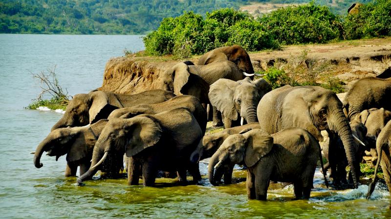
Queen Elizabeth National Park
PARK AT A GLANCE
- Size: 1,978km².
- Queen Elizabeth spans the equator line; monuments on either side of the road mark the exact spot where it crosses latitude 00.
- The park was founded in 1952 as Kazinga National Park, and renamed two years later to commemorate a visit by Queen Elizabeth II.
- The park is home to over 95 mammal species and over 600 bird species.
The Katwe explosion craters mark the park's highest point at 1,350m above sea level, while the lowest point is at 910m, at Lake Edward.
Queen Elizabeth National Park is understandably Uganda’s most popular tourist destination. The park’s diverse ecosystems, which include sprawling savanna, shady, humid forests, sparkling lakes and fertile wetlands, make it the ideal habitat for classic big game, ten primate species including chimpanzees and over 600 species of birds.
Set against the backdrop of the jagged Rwenzori Mountains, the park’s magnificent vistas include dozens of enormous craters carved dramatically into rolling green hills, panoramic views of the Kazinga Channel with its banks lined with hippos, buffalo and elephants, and the endless Ishasha plains, whose fig trees hide lions ready to pounce on herds of unsuspecting Uganda kob.
As well as its outstanding wildlife attractions, Queen Elizabeth National Park has a fascinating cultural history. There are many opportunities for visitors to meet the local communities and enjoy storytelling, dance, music and more. The gazetting of the park has ensured the conservation of its ecosystems, which in turn benefits the surrounding communities.
Uganda’s Queen Elizabeth National Park is truly a Medley of Wonders!
-
National Park
Lake Manyara National Park
Park history
Lake Manyara National Park delivered its name from a plant called Euphorbia tirucalli, known as Emanyara in Maasai language. The Maasai are using this plant to protect their bomas (hedge). The Park was gazette as a National park in 1960 and was declared as Man and Biosphere Reserve in 1981. The park has an area of 648.7 km2 (402 sq miles) of which 262.7 km2 (163 sq miles) is covered by lake and 386 km2 (240 sq miles) is dry land.
The rainfall pattern of the park is bi-modal with short rains starting from November to December and long rains from February to May, dry season is from late June to October, annual mean temperature is 26.50C, average temperature 11.340C and relative humidity ranges from 45%-85%.
How to get there
The park is located in Northern Tanzania, 126 km west of Arusha town along the Makuyuni-Ngorongoro road, strategically located along the high way to Ngorongoro and Serengeti and is easily accessible by road and air (charter or scheduled flights). The park is close to the ethnically diverse town of Mto wa Mbu in which a representation of the 120 tribes of Tanzania is found.
Best time to visit
The park can be accessed throughout the year. However, June to October is the best time for large mammals and November to July is ideal time for bird watching.
Available activities
GAME VIEWING
Day Game Viewing
This activity is conducted during the day and night. For day game drive the activity is conducted from 06:30 – 18:30 hrs
Night Game drive
Night game driveis carried out from 19:00 – 23:00 hrs, no additional fee for day game drive but for night game drive (NGD) there is an additional fee. Four-wheel (4x4) drive vehicles are recommended.
For night game drive booking is recommended for arrangement of an armed park ranger
Areas for conducting night game drive
- Northern zone - Groundwater forest, Hippo pool, Flood plain, Msasa and Endalla areas.
- Central zone – Endabasha forest, Cetral Lakeshore, Majimoto ndogo and Bagayo areas
- Southern zone - Sothern lakeshore, Iyambi, Array river confluence and Majimoto kubwa areas.
- Common nocturnal animal sightings; - Crested Porcupine, Greater and Senegal Galago, Civet, Common Genet, White tailed Mongoose, Lion, Hippos (grazing) and species of birds like Owls, Nightjars and Dikkops.
Additional fees apart from Conservation fees for Night game drive
|
Category |
Age Group | Ranger fee/Group | |
| Adult | Child | ||
|
Non East Africa Citizens/ Tanzania Expatriates |
US $ 50 |
US $ 25 |
US $ 20 |
| East African Citizens | |||
Walking safari
Include short walking safari from 1- 4 hours and long walking safari (above 4 hours).
There are three trails namely.
- Msasa walking trail: Start from Msasa picnic site crossing through the river gorge (2-3hrs) up to the top of the of the rift valley wall.
- Lake shore walking trail: Long walk that takes 4 to 6 hrs
- Time to conduct the activity: From 19h00 to 23h00 hours.
- Booking is necessary which help the management to prepare armed ranger.
Birding
The park offers a high diversity of bird species over 390 birds species both migrants and residents include a thousand of pink-hued flamingos on their perpetual migration as well as other large water birds such as pelicans, cormorants and storks.
What are the bird watching hotspots?
- Hippo pool view points, Boardwalk way at Majimoto and Ground water forest (the later for breeding species).
- Best time for bird watching- November to July is ideal time for bird watching.
- No additional fee for this activity.
Camping
Special campsites
- There are 3 campsites namely: Bagayo A and B and Lakeshore. All are located in the middle of the Park.
Filming
- Lake Manyara National Park is ideal place for filming, as it offers 7 wildlife habitats with abundant wildlife and diverse tourism attractions.
- Filming fee: US $ 250 charged per person/day covers (entrance, camping and filming). This applies to all nationalities.
Picnicking:
- There are 3 picnic sites (Msasa, Majimoto and Endalla)
- Picnic sites are the best areas for taking short breaks and stretching after a long drive. They are also best places for taking packed meals while on game drive. All of them are located strategically to enable visitors to enjoy their meals while having the benefit of magnificent view of the landscape and wildlife. There is provision of flush toilet, benches and tables.
View points: There are two viewing points:
1. Hippo Pool view point
It is a free standing wooden platform rising by 8feet above the ground. The viewpoint is located 8km from the main gate, while you are on top of this platform you can have spectacular view of the rift valley wall, marshland, waterfowls and animals such as Hippo, buffalo, wildebeest and zebra. This is one of the few locations where visitors are allowed to alight from vehicles and stretch legs
2. Lake Manyara view point
This view point offers spectacular panoramic view of the lake (Lake Manyara), Ground water forest, rift valley escarpment and surrounding landscapes.
3 Boardwalk way (Majimoto Boardwalk way)
Maji moto boardwalk way is featured with1.5 meters wide impressive wooden structure, creating a 325 meters long trail standing 1.5meters above the ground winding up in an observation platform that is 15 meters long and 2.5 meters wide. The trail meanders through the hot springs and lakeshore around a marsh and finally into the lake, the boardwalk way gives visitors a unique view and wonderful photo opportunities at every turn of the boardwalk trail.
No additional fee required.
4 Canopy Walkway
This is a new product that is expected to start to operate in October 2016. The structure rises gently from the ground to 17 meters high. The average height is 15 meters.
Tourist attractions
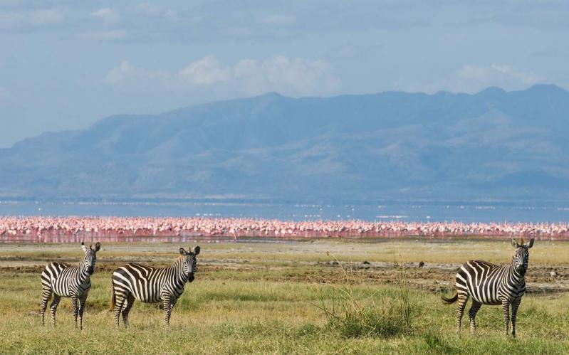
- The lake forms the most spectacular sight and waterfowl like vast number of Lesser Flamingo.
- Ground water forest in the savanna nurtured by fresh water springs
- High diversity of species of birds both local and migratory species (more 390).
- Rift Valley Escarpment forms a unique scenic beauty of the park.
- Large herd of Elephants and Buffalos
- Hot springs
- High population of Hippopotamus
-
Lake or River
-
Lake or River
-
National Park
-
National Reserve
.jpg)
Kilimanjaro National Park
Park history
In 1910 the area was declared as a game reserve and a forest reserve in 1921 before being gazetted as a national park in 1973. It was not until 1977 when Kilimanjaro was opened for public access. The park was declared by UNESCO as a world heritage site in 1987 and voted as one of the Seven Natural Wonders of Africa in 2013. Kilimanjaro is located in Northern Tanzania 48 km from Moshi town and covers an area of 1,668 square km.
How to get there
By road:123 km, a two hour drive from the city of Arusha or 48 km, an hour drive from Moshi town to Marangu Gate and 86km one hour and half drive from Kilimanjaro International Airport.
Best time to visit
Mountain climbing can be done throughout the year. However, the best time is mid June-October and December-mid March.
Tourism activities
Mountain climbing –Climbing Kilimanjaro is not just a climb but a journey from the tropics to the Arctic.The higher you climb,the colder it gets with change in vegetation zones.
Nature Walking safari – Short walking safari
- Marangu via Lauwo waterfall to Mandara (12Km)
- Machame gate to Machame hut (11Km)
- Morum barrier to Shira I (06Km)
- Rongai gate to simba camp (05Km)
Birding:
There are about 179 bird species inhabiting different vegetation zones, thus giving an opportunity to view them in different climatic zones. Birds like White Necked Raven, Lammergeyer and Alpine Chat are commonly seen in high altitude zones.
Camping:
There are 31 camping sites along the seven hiking routes: Off all the camping sites are wilderness with toilets and a park staff house
* Londorosi Route
This is an ascending route located on the western side of the mountain and it comprised of five stations namely Shira I, Shira II, Baranco, Karanga and Barafu. It also offers the chance of using the Northern circuit and Western breach.
* Lemosho route
This route is also for ascending located on the western side of the mountain and it comprised of six stations of Mti Mkubwa then join Londorosi route at Shira I.
* Machame route
This is an ascending route as well located on the South-West of the mountain and it has five stations namely Machame hut, Shira cave, Baranco, Karanga and Barafu.
* Umbwe route
It is an ascending route located on the South-West of the mountain and it has four stations, the Umbwe cave inside the forest belt and the other three after join Machame route at Baranco camp.
* Mweka route
This is a descending route located on the southern side of the mountain. It comprised of three stations namely Mweka hut, High camp (Millenium) and Barafu. Visitors form Londorosi, Lemosho, Machame and Umbwe descent using this route
* Kilema route
This route is for cycling. It has three stations namely Kilemamchele, Maua and Kibo; it is two way traffic.
* Marangu route
This is route is for ascending and descending with provision of huts along the trail. It has three stations namely Mandara, Horombo and Kibo. On the mountain stations, there are toilets, kitchens, dinning and rooms for clients. Advance booking through a licensed mountain tour operator is mandatory.
* Rongai Route
It is ascending route with an option of using four or five stations depending on the choice of the climber. Visitors who ascend through this route will descend through Marangu route. Option of four stations includes Simba camp, second cave, third cave and school hut and the second option for five stations is Simba camp, second cave, Kikelelwa, Mawenzi tarn hut and School hut.
Additional fees apart from the conservation fees
| Category | Public campsite fee | |
| Adult | Child(>16 years) | |
| Non EAC Citizens/ TZ Expatriates | US $ 50 | US $ 10 |
| EAC Citizens | TZS 10,000 | TZS 5,000 |
- Non EAC Citizens/ Tz Expatriates US $ 50
- EAC Citizens TZS 30,000
- Launching area on the mountain is explored by the operator similarly the landing site in or outside the park
- Non EAC Citizens/ Tz Expatriates US $ 200
- EAC Citizens TZS 100,000
Three peaks:
- Kibo, the highest peak (5,895m), is covered by snow throughout the year despite being close to the equator. Conquering this peak is an adventure of a lifetime.
- Mawenzi, the rugged peak (5,149m), can only be attempted by technical climb. Only people with specialized knowledge, skills and equipment are allowed.
- Shira peak: Shira (3962) is the oldest peak that collapsed some 750 years ago while before collapsing was the highest of the three.
Shira Plateau
After collapsing, the Shira peak formed a plateau of outstanding scenic beauty on the mountain. This plateau has an open grassland, heath and moorland with a large concentration of endemic plants including Senecio and lobelias. While on the plateau, one can visit the Shira central cone, the Cathedral and the Needle. Several kinds of migratory mammals such as buffaloes, elephants and elands use this plateau for feeding or salt licking.
Montane Forest
It’s in this area, one finds the largest known population of Abbot’s duiker and various plant species, including endemic plants like Impatiens kilimanjari. Walking through this belt takes ones breath away.
Climbing Tips
- Observe and adhere to all park rules and regulations
- Climbers are advised to have appropriate climbing gears
- Allow plenty of time for the body to acclimatize by ascending slowly
- Do not push yourself up the mountain if your body is exhausted or you have extreme mountain sickness
- Drink 4 - 5 liters of fluid each day. Water is the best but fruit juices are good supplement
- If symptoms of mountain/high altitude sickness persist please descend immediately and seek medical treatment. Our rescue team is always stand-by for evacuation to nearby hospitals.
-
Mountain
-
Mountain Climbing
-
National Park
-
National Reserve
-
Wildlife Conservancy
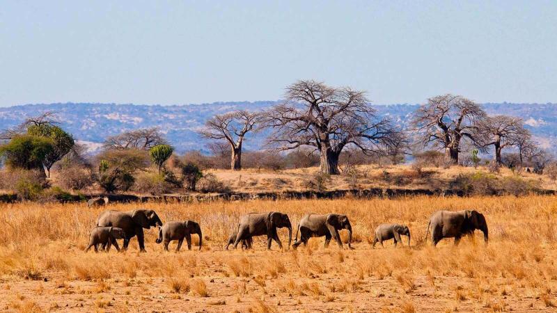
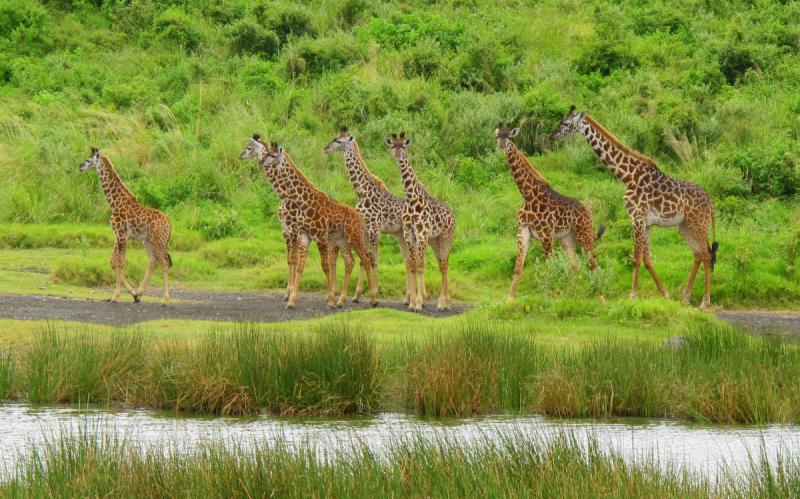
Tarangire National Park
The park is famous for its high density of elephants and baobab trees. Visitors to the park in the June to November dry season can expect to see large herds of thousands of zebra, wildebeest and cape buffalo. Other common resident animals include waterbuck, giraffe, dik dik, impala, eland, Grant's gazelle, vervet monkey, banded mongoose, and olive baboon. Predators in Tarangire include African lion, leopard, cheetah, caracal, honey badger, and African wild dog.
The oldest known elephant to give birth to twins is found in Tarangire. A recent birth of elephant twins in the Tarangire National Park of Tanzania is a great example of how the birth of these two healthy and thriving twins can beat the odds.
Home to more than 550 bird species, the park is a haven for bird enthusiasts. The park is also famous for the termite mounds that dot the landscape. Those that have been abandoned are often home to dwarf mongoose.
In 2015, a giraffe that is white due to leucism was spotted in the park.Current wildlife research projects in the park include the Tarangire Elephant Project, Tarangire Lion Project, and Masai Giraffe Conservation Demography Project.
-
Lake or River
-
Lake or River
-
National Park
-
National Reserve
-
Wildlife Conservancy
Arusha National Park
The closest national park to Arusha town – northern Tanzania’s safari capital – Arusha National Park is a multi-faceted jewel, often overlooked by safarigoers, despite offering the opportunity to explore a beguiling diversity of habitats within a few hours.
The entrance gate leads into shadowy montane forest inhabited by inquisitive blue monkeys and colourful turacos and trogons – the only place on the northern safari circuit where the acrobatic black-and-white colobus monkey is easily seen. In the midst of the forest stands the spectacular Ngurdoto Crater, whose steep, rocky cliffs enclose a wide marshy floor dotted with herds of buffalo and warthog.
Further north, rolling grassy hills enclose the tranquil beauty of the Momela Lakes, each one a different hue of green or blue. Their shallows sometimes tinged pink with thousands of flamingos, the lakes support a rich selection of resident and migrant waterfowl, and shaggy waterbucks display their large lyre-shaped horns on the watery fringes. Giraffes glide across the grassy hills, between grazing zebra herds, while pairs of wide-eyed dik-dik dart into scrubby bush like overgrown hares on spindly legs.
Although elephants are uncommon in Arusha National Park, and lions absent altogether, leopards and spotted hyenas may be seen slinking around in the early morning and late afternoon. It is also at dusk and dawn that the veil of cloud on the eastern horizon is most likely to clear, revealing the majestic snow-capped peaks of Kilimanjaro, only 50km (30 miles) distant.
But it is Kilimanjaro’s unassuming cousin, Mount Meru - the fifth highest in Africa at 4,566 metres (14,990 feet) – that dominates the park’s horizon. Its peaks and eastern footslopes protected within the national park, Meru offers unparalleled views of its famous neighbour, while also forming a rewarding hiking destination in its own right.
Passing first through wooded savannah where buffalos and giraffes are frequently encountered, the ascent of Meru leads into forests aflame with red-hot pokers and dripping with Spanish moss, before reaching high open heath spiked with giant lobelias. Everlasting flowers cling to the alpine desert, as delicately-hoofed klipspringers mark the hike’s progress. Astride the craggy summit, Kilimanjaro stands unveiled, blushing in the sunrise.
About Arusha National Park
Size: 552 sq km 212 sq miles).
Location: Northern Tanzania, northeast of Arusha town..
Getting there
An easy 40-minute drive from Arusha. Approximately 60 km (35 miles) from Kilimanjaro International Airport. The lakes, forest and Ngurdoto Crater can all be visited in the course of a half-day outing at the beginning or end of an extended northern safari.
NOTE: Mountain Climbing Permits duration time is 12 HOURS.
What to do
Forest walks, numerous picnic sites;
three- or four-day Mt Meru climb - good acclimatisation for Kilimanjaro.
When to go
To climb Mt Meru, June-February although it may rain in November.
Best views of Kilimanjaro December-February.
Accommodation
Two lodges, two rest houses, camp sites, two mountain huts inside the park; more lodges at Usa River outside the park and many hotels and hostels in Arusha town.
-
National Park
-
National Reserve
-
Wildlife Conservancy
.jpg)
Volcanoes National Park
The “Parc National de Volcans” (or PNV as it’s known by locals) lies along the Virunga Mountains, with 8 ancient volcanoes, which are shared by Rwanda, Uganda and the Democratic Republic of Congo. Just a short two hour drive from Rwanda’s capital of Kigali, the park is a central location for exploring some distinctly Rwandan experiences. While a visit to the mountain gorillas is often at the top of visitor, the dramatic landscape also offers thrilling hiking and visits to the fascinating golden monkeys.
PNV is also one of Rwanda’s conservation epicenters, where many non-profit organizations base their operations. Visitors can pay homage to the legendary scientist and gorilla advocate Dian Fossey with a hike to her tomb or a visit to the Dian Fosse Gorilla Fund that continues her legacy of research and advocacy to this day.
Near the park, the bustling and vibrant markets of Musanze are a place to immerse yourself into everyday Rwandan culture. Go deep into the earth with Musanze’s caves – one of the area’s newest attractions.
Tracking the endangered mountain gorillas on the slopes of the Virunga volcanoes is a magical experience. Hike through mountain forests to experience these gentle creatures or make your way through airy bamboo forests to find the charming Golden Monkey.
Also available is the ‘Dian Fossey Tomb Trail’ – a beautiful yet challenging hike to 3,000 meters up the slopes of Mount Bisoke or a hike to the beautiful Ngezi Crater Lake at the top.
- Permit costs per person:
- Mountain Gorillas: US$ 1500
- Dian Fossey Hike: US$ 75
- Golden Monkey Tracking: US$ 100
- Crater Lake Hike: US$ 75 Permits should be booked 3 to 6 months in advance, especially during Rwanda's high season of June - September. To make reservations for any of the above activities, contact RDB's Reservation Centre.
Munsanze Caves
Rwanda’s caves date back 65 million years and lie withing the volcanic region where lava flow layers long ago created the Albertine Rift Valley. The caves offer easy hiking 2 kilometers in distance and have brilliant views of cascading lights from the surface, unique rock formations, and a colony of bats.
- Contact RDB’s reservation center to arrange your caving trip.
Buhaga Echo Park
Despite its small size, this serene forest packs a great deal of biological and cultural significance. Meditative trails cross through towering trees home to a variety of bird and butterfly species. The location is built on an ancient sacred site that was used for coronation rituals of Rwandan kings.
- Permits cost $40 per person.
- Tours run between 10:00 am and 3:00 pm and can be arranged by contacting RDB’s reservation center.
Iby'Iwacu Cultural Village
Located just outside the national park, this living museum highlights aspects of traditional Rwanda society. Visitors can expect to be greeted by thunderous drumming, joyful dancing, and the kind of hospitality that has permeated Rwandan society for centuries. The village features hands-on activities related to the rituals and ways of life in the ancient Rwandan kingdom. Some of Iby’Iwacu’s presenters and performers were previous poachers who’ve now been able to make a new livelihood through this memorable, interactive stop designed for visitors of all ages. The village also offers extended trips into the countryside as well as overnight lodging that can be arranged in advance.
-
Birding Site
-
Forest
-
Mountain
-
Mountain Climbing
-
National Park