- Home
- Attractions
- All Attractions
- ATTRACTIONS PROFILES
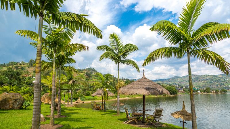
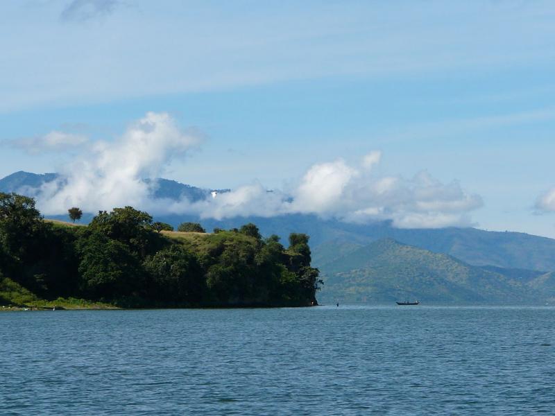
Rubavu/ Lake Kivu
If you’re surprised that Rwanda has a beach – you’re not alone. Rubavu (also known as Gisenyi) is a waterfront town located on the shores of Lake Kivu, one Africa’s great bodies of water. At only an hour away from Volcanoes National Park, Rubavu is a great way to unwind after trekking adventures.
Rubavu marks the beginning of the Congo Nile Trail, which extends 227 km to Rusizi, and has plenty of biking and hiking trails to fulfill those who crave the some more adventure. Rubavu is also known for its agrotourism experiences, with many tea and coffee plantations nearby.
Sea’ Kayak on Lake Kivu
Journey along the verdant shores
Lake Kivu is stunningly beautiful lake and an incredible place to visit. With no hippos or crocodiles and crystal clear, clean water, it is also one of the safest lakes in Africa. So come and explore, discover and journey along its interesting coastline. Watch unique fishing boats plying the water and find interesting villages as well as amazing birdlife set amongst true peace and tranquillity.
Near to Rubavu (Gisenyi), coffee enthusiasts can see how coffee is grown and made in to a delicious cup of famous Rwandan coffee. And not far from Karongi (Kibuye) is Rwanda’s own ‘Bay of Islands’ where many uninhabited islands are covered with natural woodland and even a remarkable colony of bats. However, it is making the journey silently and quietly along the coast that is the really special part of ‘sea’ kayaking on the lake.
Using their own modern and very stable sea kayaks that are designed for touring, Kingfisher Journeys operates one and two-day small group, guided tours from both Rubavu (Gisenyi) and Karongi (Kibuye) as well as four-day journeys between these lakeshore towns.
Most tour operators can also include ‘sea’ kayaking on Lake Kivu with their other activities and a full Rwandan itinerary.
-
Lake or River
-
Lake or River
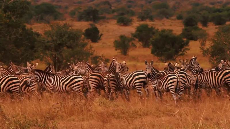
Mokamazi National Park
Park history
Formerly a Game Reserve since 1951, Mkomazi was upgraded into a ‘National Park’ status in 2008. It is located 6km from Same town, covering an area of 3,245square km. The name ‘Mkomazi’is a combination of two words from the Pare ethnic language; “Mko and Mazi”. “Mko” means a traditional tiny wooden spoon used by the Pare people for eating and “Mazi” means water. This implies that water in the Park is hardly enough to fill up the wooden spoon.
How to get there by Road:
- Mkomazi is located north eastern Tanzania 120km from Moshi, 155km from
- Kilimanjaro International Airport, 200km from Arusha and 500km from Dar esalaam via Same town.
By Air:
- Several companies arrange charter flights to Mkomazi.
Best time to visit: June - January.
Tourism activities
- Game drives – This activity is conducted from 0630 – 1830 HRS, no additional fee for this activity. Four wheel (4X4) drive vehicles are recommended.
- Short walking safari: Dindira trail (4km) which takes about 3hrs
- Hiking: Mbula Hill Trail (5km) which takes about 4hrs to ascend and descend. The best time to conduct the activity is early morning and late afternoon. Bookingthrough mkomazi@tanzaniaparks.go.tz is mandatory.
Additional fees apart from conservation fees:
| Category | Short walking/ hiking fees | Ranger service fee/group | |
| Adult | Child (>12 yrs) | ||
| Non EAC Citizens/ Tz Expatriates | US $ 20 | US $ 10 | US $ 20 |
| EAC Citizens | TZS 5,000 | TZS 2,500 | TZS 5,000 |
Birding:
There are more than 450 bird species including those that are hardly seen elsewhere such as Friedmann’s Lark, the Violet Wood-hoopoe, Somalia Long Billed Crombec and Shelley’s Starling. Also,the park host Eurasian migrant birds such as European Roller. Best sites for birds watching are Zange, Dindira, Mbula, Babus, Norbanda, Ngurunga and Maore.
Camping:
Special campsites: There are two special campsites; Dindira and Mbula. Booking through mkomazi@tanzaniaparks.go.tz or booking@tanzaniaparks.go.tz is mandatory.
Public campsites: Zange and Maore campsites. Available facilities at Zange include bathroom, toilet, kitchen and dining.
| Category | Special campsite fee | Public campsite fee | ||
| Adult | Child | Adult | Child | |
| Non EAC Citizens/ Tz Expatriates | US $ 50 | US $ 10 | US $ 30 | US $ 5 |
| EAC Citizens (TZS) | 10,000 | 5,000 | 5,000 | 2,500 |
Additional fees apart from conservation fees
Filming:
Filming fee: US $250 charged per person/day and covers conservation, camping and filming fees. This is applicable to all nationalities.
Refer Filming guidelines
Picnicking:
This is available at Vitewini and Dindira picnic sites. The latter provides a stunning view of the park. They are best places for taking packed meals while on game drive. No additional fee required.
Main Tourist attractions
- Diversity of Fauna and Flora, the only protected area in Tanzania with large and visible population of Gerenuk.
- Magnificent view of landscapes including Kilimanjaro, Eastern Arc Mountains (Pare and Usambara), associated Hills and Acacia Commiphora Woodland.
- Endangered species of animals particularly Black Rhino and Wild dogs
Accommodation
Inside the park: One Tented Camp, and several special and public campsites.
Outside the park: Several hotels, guest houses and camps in the nearby Same town.
Love nature please observe park rules and regulations and kindly note:
- The gate is opened at 6:00am and closed at 6:30pm
- Payment in the park is through Visa card, Master card, CRDB or Exim card
- Do not exceed speed limit of 50K.P.H; the recommended speed for game viewing is 25K.P.H
- Keep to the authorized roads and tracks
- Do not light any fire or discard any burning object
- Do not litter
- Do not disturb wild animals; do not make noise, never blow your horn
- Do not pick, cut or damage any plant or part of it or possess any wild animal or part of it
- Do not feed wild animals
- Fees are valid for 24hrs single entry
-
Birding Site
-
Game Reserve
-
National Park
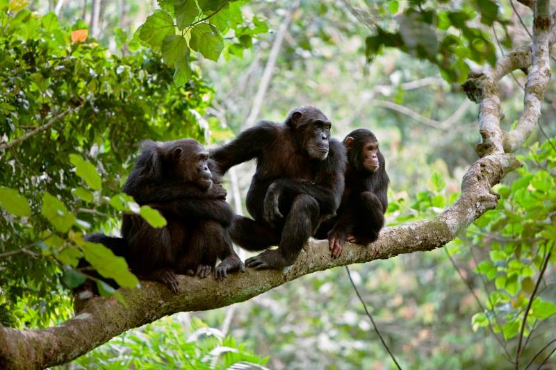
Gombe National Park
Park history
Gombe, designated as a game reserve in 1943, was upgraded into a national park status in 1968. The park is located 16 km north of Kigoma town on the shores of Lake Tanganyika in western Tanzania. It covers an area of 56 square kilometers and is a fragile habitat for chimpanzee. Gombe gained its popularity after the research of Dr Jane Goodall which isbelieved to be the longest running study of primates in the world.
How to get there
By boat: Board public boat (up to four hours) or motor boat (two hours). The motor boat can be booked throughgombe@tanzaniaparks.go.tz or directly at the park information center located in Kigoma town.
To get to Kigoma:
- By air: scheduled flights from Dar es Salaam and Mwanza cities or from Arusha by chartered flights.
- By rail: from Dar es Salaam or by ferry from Mpulungu in Zambia.
- By road: from Dar es Salaam, Arusha or Mwanza.
Best time to visit
Chimpanzee can be trekked throughout the year. However, for plants/insects and better chimpanzee spotting, the best time is during wet season (November to mid May) and for the best photo taking (May to October).
Tourism activities
Chimpanzee trekking– This activity is conducted from 0630 – 1830 hrs.
Additional fees apart from the conservation fee
| Category | Guiding fees per group (not exceeding six people) |
| Non EAC Citizens/ Tz Expatriates | US $ 20 |
|
EAC Citizens |
Walking safari –Short walks along the shores of Lake Tanganyika or to Janes View Point
This view point offers a spectacular view of the park and Lake Tanganyika. While at the view point one can hear chimpanzee calling and screaming. The hike takes about two hours from kasekela. No Additional fees apart from the conservation fees
Birding
Over 200 birds species fly around, varying from the African crowned eagle that hunts monkeys, to the iconic fish eagle, three kinds of kingfisher and the bright Peters twins pots. Another remarkable character is the palm-nut vulture; a near-vegetarian common to Lake Tanganyika that prefers fruits over carcasses.
Filming:
- Hugo van Lawick in 1988 filmed people of the forest – the chimps of Gombe.
- Filming fee: US $ 180 charged per person/day and covers conservation, camping and filming fees. This is applicable to all nationalities.
- Filming guidelines and Filming application form. PDF
Main Tourist attractions
- Kakombe and Mkenke waterfall
- Lake Tanganyika
-
National Park
.jpg)
Katavi National Park
Park history
Formerly a game reserve, the park was established in 1974. The park is located 40km south of Mpanda town, being Tanzania’s third largest national park it covers an area of 4,471 square km after Ruaha and Serengeti.
How to get there
- By Air: Several companies arrange charter flight from Dar es Salam, Mwanza or Arusha cities to either Mpanda airport which is located in Mpanda town or to Sitalike and Ikuu airstrips inside the park.
- By Road: From either Dar es Salaam via Mbeya (1513Km), Arusha via Tabora (1015.7km) or Mwanza via Mpanda (741 km).
- By Rail: It is also possible to reach Mpanda by train from Dar es Salaam via Tabora then catch a public transport to Sitalike, where game drives can be arranged.
Best time to visit
- May to October and mid December.
Tourism Activities
- Game drives – This activity is conducted from 0630 – 1830 HRS, no additional fee for this activity. Four wheel (4X4) drive vehicles are recommended.
- Walking safari – Short walking safari
Additional fees apart from conservation fees:
| Category | Short walking fees | Long walking fees | Ranger fee/group | ||
| Adult | Child (>12 yrs) | Adult | Child (>12 yrs) | ||
| Non EAC Citizens/ Tz Expatriates | US $ 20 | US $ 10 | US $ 25 | US $ 15 | US $ 20 |
| EAC Citizens | TZS 5,000 | TZS 2,500 | TZS 5,000 | TZS 5,000 | TZS 5,000 |
Birding:
The park is rich with various bird species. There is no additional fee for this activity.
Camping: – Two types
- Special campsites: pre booking through booking@tanzaniaparks.go.tz is mandatory.
- Public campsites: Available services and facilities include Kitchen, bathroom, toilet and water.
| Category | Special campsite fee | Public campsite fee | ||
| Adult | Child | Adult | Child | |
| Non EAC Citizens/ Tz Expatriates | US $ 50 | US $ 10 | US $ 30 | US $ 5 |
| EAC Citizens | TZS 10,000 | TZS 5,000 | TZS 5,000 | TZS 2,000 |
Bush meals: Site for bush meals can be arranged for you upon request.
Additional fees apart from the conservation fees.
| Category | Bush meal fee | |
| Adult | Child | |
| Non EAC Citizens/ Tz Expatriates | US $ 5 | US $ 5 |
| EAC Citizens | TZS 5000 | TZS 5000 |
Filming:
- Filming fee: US $250 charged per person/day and covers conservation, camping and filming fees. This is applicable to all nationalities. Remember to obtain filming permits from the Ministry of information, sports and culture and then from the office of the Director General -TANAPA HQ
- Night Game Drive: (Refer guidelines and fee structure for the activity)
- Picnicking:They are best places for taking packed meals while on game drive. No additional fee required.
Main Tourist attractions
- Hippos and Crocodiles
- Lake Chada
- Katuma River
- Wildlife abundance
Accommodation
- Inside the park: Rest house, bandas and campsites (booking through the park). Several privately owned luxury tented lodges.
- Outside the park: Several lodges and hotels at the village of Sitalike and Mpanda town.
-
National Park
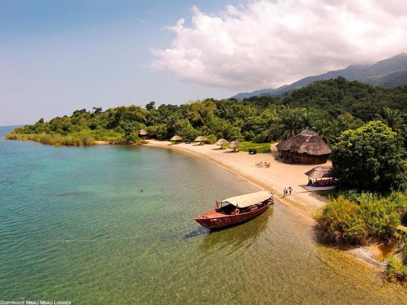
Mahale National Park
Park History
Mahale Mountains National Park is home to some of the Africa last remaining wild chimpanzees and estimated to have roughly more than 800 residing in this area. Some of them are habituated to human.
This area was traditionally inhabited by the Batongwe and Holoholo people. Tongwe is a small ethnic group of Bantu, therefore this park is situated at the center of Tongwe Land that includes south of the Kigoma Region and north of the Katavi Region. The people had been highly attuned to the natural environment, living with visually no impact on the ecology.
The park was officially declared a National Park in 1985. Set deep in the heart of African interior, a road free park located about 128 km south of where Stanley uttered that immortal greeting '' Dr Livingstone, I presume''. It is a scene reminiscent of an Indian Ocean Island beach idyll. Silky white coves hem in the sapphire waters of Lake Tanganyika, overshadowed by a chain of wild, jungle draped peaks towering almost 2 km above the shore; the remote, pristine and mysterious Mahale Mountains.
How to get there
- By Air: Mahale can be reached by chartered flight from Kigoma.Dar es salaam,Mwanza, Arusha or any airport in Tanzania.
- By boat: From Kigoma town it takes 3-4 hrs (by speed motorboat upon prior arrangement with the park), or Twice per month Mv Liemba ferry from Kigoma (8-10hrs) to Lagosa point then arrange a boat with the park to pick you to the park.
- By road: From Kigoma to nearby villages through Simbo junction (4hrs) then arrange for boat pick up to the park which takes about half an hour cruising through the lake
Best time to visit
The park can be visited throughout a year; however, the best time is during the dry season (May – November) but can be visited also in wet season (December - April), however you will need additional gears such as rain coat and boot for trekking and walking safari.
Available activities
Chimpanzee Tracking: This activity is conducted from 06.30 to 18.30HRS.
Additional fees apart from the conservation fee.
| Category | Guiding fee per group (not exceeding 6 people) |
| Non- EAC citizens/expatriates | US $20 |
| EAC citizens | TZS 5,000 |
Walking Safaris
| Category | Long walk (above 4 hrs) | Short Walk (1- 4hrs) | ||
| Adult | Child(>12yrs) | Adult | Child(>12yrs) | |
| Non EAC Citizens/ TZ Expatriates | US $ 25 | US $ 15 | US $ 20 | US $ 10 |
| EAC Citizens | TZS 10,000 | TZS 5,000 | TZS 5,000 | TZS 2,500 |
Kayaking Fees
| Category | Kayaking Fee |
| Non EAC Citizens/ Tz Expatriates | US $ 10 |
| EAC Citizens | TZS 5,000 |
Sport Fishing
| Category | Sport Fishing fee | |
| Adult | Child | |
| Non-EAC Citizens/TZ Expatriates | US $25 | US$ 10 |
| EAC Citizens | TZS 10,000 | TZS 5,000 |
Camping
| Category | Public Campsite | |
| Adult | Child | |
| Non EAC Citizens/ Tz Expatriates | US $ 30 | US $ 5 |
| EAC Citizens | TZS 5000 | TZS 2,500 |
Main Tourist attractions (Main attractions)
Chimpanzees
These are species of Ape which is the most humanity’s closest living relatives. Research of wild chimpanzees teaches us ''man's place in nature'' and provides us with key information that is relevant to re-constructing the social life of early man. Long term field studies on chimpanzees revealed many important facts about them such as hunting, tool-using, medicinal use of plants, social intelligence and existence of culture. Mahale National Park has the highest remaining wild chimpanzee's population in Africa.
This is the highest point in Mahale mountains range which bisects the park from NNW to SSE running about 50 km long. This area was held sacred by local Tongwe people. Hiking Nkungwe peak increases visitor’s satisfaction as the slopes supports diverse flora and fauna troops of red Colobus, red tailed and blue monkeys, black and white colubus monkey and colourful birds as well
Lake Tanganyika
Set about 770 meters above sea level, provides swimming opportunity in impossibly clear waters of the world's longest (720km), second deepest (1435m) and least polluted fresh water lake providing aquatic habitat to estimated more than 1000 species
Accommodation
Accommodation in the park includes five self- contained bandas (twin beds), luxury tented camps and camping sites both public and special campsites. Park bandas offers kitchen cooking facilities which requires visitors to come along foods
Park rules and regulations
- Keep to the authorized trails.
- Do not disturb wild animals in any way. Do not make noise.
- Be considerate to fellow visitors – do not disturb them or the animals they are watching.
- Do not take any pets or guns into the park.
- Do not uproot, pick, cut or damage any plant or be in possession of any part of a plant indigenous to the park.
- Do not light any fire or discard any burning object.
- Do not discard any litter.
- Between 7:00p.m and 6:00a.m. remain in the immediate vicinity of designated accommodation facilities (tented camps, tourist bandas, rest house or campsites).
- A permit is valid for single entry within 24 hours only.
-
National Park
.jpg)
Rubondo National Park
- By road :From Mwanza to Muganza/Kasenda via Chato (260km) and then by boat to the park (8km) From Mwanza to Nkome via Geita (193km) and then by boat to the park (30km)
Boat hiring fees (return trip): From Kasenda From Nkome
- EAC Citizens TZS 100,000 TZS 340,000
- Non EAC Citizens (NR) US$ 100 US$ 190
- June- August(dry season) is the best time to watch large animals, butterflies and wild flowers.
- November- March (wet season) is the best time for watching migratory as well as breeding resident birds.
-
National Park
Saanane National Park
Park history
Saanane, the rocky Island in Lake Victoria was named after its former owner Mzee Saanane Chawandi, who was a farmer and fisherman. The Island was established as the first zoo in Tanzania in 1964 whose objectives were to promote interest in wildlife conservation education and provide recreation to Mwanza people. Between 1964-1968, the Island was stocked with an array of wildlife species, many of which were released into Rubondo Island National Park.
In 1991, the Government declared the Saanane Island as a Game Reserve to promote and strengthen conservation. It was fully fledged as the 16th National Park in July 2013, covering an area of 2.18 Km2 including aquatic environment, dry land. The Park is made up of other two smaller islets; “Chankende Kubwa” and “Chankende Ndogo”, which lie in the south. The Saanane Island is the smallest and first ever National Park located within Mwanza city Tanzania.
How to get there
Stepping into the city of Mwanza (the rocky city) is much easier by air, road, train and water transport means. Saanane Island is easily accessed using a boat skip taking five minutes from a dock located a walking distance about 15mins from the city centre.
Best time to visit
All year round is possible: birdlife is most varied and scenery greenest over November-March. June-August is the dry season and great for iconic, game viewing and rock hiking.
Main tourist attractions
- The National Park is in a rocky city, dominated with massive and highly weathered granite boulders looking funnily and precariously overhanging, acting as the iconic city features.
- It is a home of mammals like Zebras, Impalas, Rocks Hyraxes, Velvet Monkeys, Fish, Water otter and Wild cats. The presence of a very shy “De-brazas Monkey” underscores its potential as the only National Park in the country harbouring the species.
- Lioness has been introduced as well. It is caged
- Reptiles are also dominant, namely; Crocodiles, Monitor Lizards, Agama Lizards, Pancakes and Leopard tortoises and snakes particularly Pythons.
- The aquatic part of the National Park renders a better habitat for a variety of fish, mainly Tilapia and Nile Perch. Ecologically, the Saanane Island environment peculiarly and splendidly forms one of the best breeding habitats for Crocodiles and Fish in Lake Victoria
- For bird watchers, Saanane Island offers unsurpassed paradise, where more than 70 bird species have been recorded including both resident and migratory birds utilizing terrestrial and aquatic environment
- The local community (Sukuma) cultural dance performance at cultural centers such as Bujora offers fabulously exciting experience worthy visiting to appreciate the pristine African cultures
Accommodation and other services
- Mwanza city is awash with a number of hotels and guest houses to suit all client tastes and budgets
- There is one public campsite in the Park
- A shop selling refreshment has been opened in the Island National Park
Available activities
Hiking that is natural gymnastic experience is an exclusive activity to do while in the National Park, besides game viewing
| Age group | Citizenship | |||
| Expatriate | Non-east African | East African | ||
| A: Entry fee | ||||
| 16 years and above | 15 US$ | 30 US$ | 5,000 Tsh. | |
| Age between 5-15 years | 5 US$ | 15 US$ | 2,000 Tsh | |
| Below 5 years | Free | Free | Free | |
| B: Boat charges | ||||
| Go and return trip | 35 US$ | 35 US$ | 35,000 Tsh. | |
| Lake excursion – 1 hour | 100 US$ | 100 US$ | 200,000 Tsh. | |
| Lake excursion – 30 minutes | 50 US$ | 50 US$ | 100,000 Tsh. | |
| C: Camping fee | ||||
| 16 years and above | 15 US$ | 30 US$ | 5,000 Tsh. | |
| Age between 5-15 years | 5 US$ | 15 US$ | 2,500 Tsh. | |
| Below 5 years | Free | Free | Free | |
| D: Sport fishing fee | ||||
| 16 years and above | 10 US$ | 20 US$ | 10,000 Tsh. | |
| Age between 5-15 years | 5 US$ | 10 US$ | 5,000 Tsh. | |
| Fishing rod hiring for 4 hours | 20 US$ | 20 US$ | 20,000 Tsh. | |
| Fishing boat hiring for 4 hours | 50 US$ | 50 US$ | 100,000 Tsh. | |
| E: Video shooting, lawn field hiring, bush lunch and tent hiring | ||||
| Video shooting in the Park | 50 US$ | 100 US$ | 100,000 Tsh. | |
| Shooting at the Park office ground | 500 US$ | 50 US$ | 50,000 Tsh. | |
| Lawn field hiring | 5 US$ | 500 US$ | 1,000,000 Tsh. | |
| Bush-lunch | 10 US$ | 5 US$ | 5,000 Tsh. | |
| Hiring a tent for two people capacity per day | 50 US$ | 10 US$ | 20,000 Tsh. | |
-
National Park
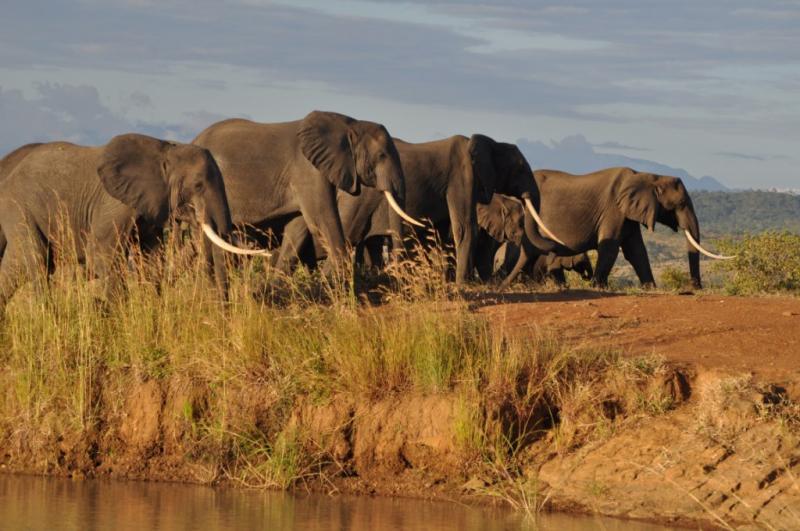
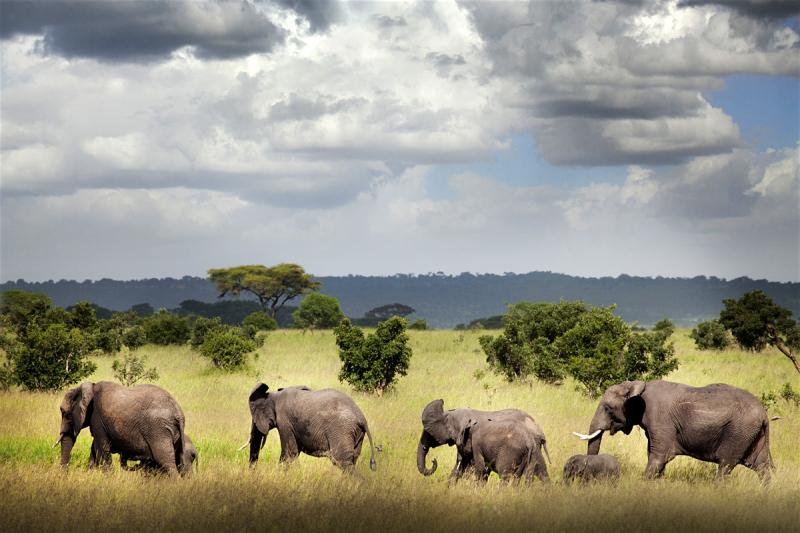
Mikumi National Park
“Wildlife at a glance”
History
Mikumi National Park is lying just to the North of the famous Selous Game Reserve. Gazetted in 1964 covering an area of 1070 km2, it was later extended in 1975 to cover the current area of 3,230 km2. The park is the fifth largest National Park in Tanzania, it Shares the name ‘Mikumi’ with the village just beyond its Western border of the Dar es Salaam – Iringa highway, which traverse the park for 50km. The small town in turn takes the name from the palm tree (Borassus spp.) which once grew there in profusion but no stem is visible in the village.
How to get there:
- By road: About288 km from Dar es Salaam; a four hours drive.
- By railway: From Dar es Salaam to Man’gula and from Man’gula using road to reach the park.
- By aircraft: The Park can also be reachable by Charter flights
Best time to visit
The best time to visit the park is during the dry season (May- October). However, the Northern part of the park is accessible through- out the year.
Tourism Activities
- Game drives – This activity is conducted from 0630 – 1830 HRS, no additional fee for this activity. Four wheel (4X4) drive vehicles are recommended.
- Walking safari – Short walking safari
- There are 3 walking trails: Kikoboga, Vuma and Lodge.
- The total distance for all trails is 14 kms where by Kikoboga 4 km, Vuma 6 km and Lodge 4 km
- The walking duration for the trails is 1.30 HRS for Kikoboga, 3 hrs for Vuma and 1.30 HRS for Lodge
- The best time to conduct walking is from 0630 to 0900 and 1600 to 1830HRS
- Booking must be done in 12 to 24 HRS
Birding:
More than 400 bird species has been recorded. The colorful common residents are lilac-breasted roller, yellow-throated long claw, eagles and a host of European migrants
Camping:
- Special campsites: There is one special campsite located at Vuma area and it is normally known as campsite no 4. Pre booking through mikumi@tanzaniaparks.go.tz / mikumi.tourism@tanzaniaparks.go.tz is required.
- Public campsites:There are 3 public campsite located at Mkata plain and Vuma hills, they are also known as campsite no 1 at Mkata plain, Campsites no 3 and 5 at Vuma hills. All required facilities such as Bath rooms, Toilets and water are available.
Picnicking:
The Park has 2 picnic sites namely Mbuyu or Millennium and Kisungura, they are located in Mkata Plain. They are best places for taking packed meals while on game drive. No additional fee required.
Main attractions
- The spectacular concentration of variety of animals in Mkata flood plain including four of the big five, elephant, buffalo, Lion and Leopard.
- The ever changing skies and light producing glorious sunrise and sunset.
- Other games including the worlds’ largest Antelope – Eland, Greater Kudu, Sable Antelopes, Defassa waterbuck and African hunting dogs.
- Mikumi offers an outstanding diversity of bird life. From the striking turkey-sized group hornbill to the tiny sunbirds. Eagles are often seen soaring in the intense blue skies, and the Lilac-breasted rollers add brilliance to their background.
- Mikumi has a variety of vegetation types ranging from seasonally flooded grassland to woodland and riverine forest. The Afromontane forest found on the summit of Malundwe Mountains is part of forest type that is renowned for its unique flora and fauna
Accommodation
- Inside the park: There are park’s Tourist bandas, rest house and three
- Private tented camps and campsites (both public and special).
- Public Campsites have basic facilities namely toilet, kitchen, water and bathroom. Special campsites are just natural sites where water and bathrooms facilities are not provided.
-
National Park
Ruaha National Park
Park history
Established in 1910 as a Game Reserve, Ruaha was gazetted a National Park in 1964. The park, covering an area of 20,226 square km, is the largest in Tanzania and second largest in Africa. Ruaha is located 125 km west of Iringa town.
How to get there
By road: 625 km from Dar es Salaam city, approximately 10 hrs drive, 125 km from Iringa, about 3hrs drive on rough road.
By Air: The Park is also reachable by scheduled and chartered flights from either Dar es Salaam, Arusha, Zanzibar, Dodoma or any other airport in Tanzania.
Best time to visit
May- October (dry season) and November-April (wet season)
Tourism activities:
Game drive – This activity is conducted from 0630 – 1830 HRS, no additional fee for this activity apart from conservation fee. Four wheel (4X4) drive vehicles are recommended.
Walking safari -Short walking safari: Designated routes are: Msembe to Ibuguziwa(4.8 km) 3hrs, Nyamakuyu to Ibuguziwa (3.6 km) 2.30 hrs, Kiganga kopjes to Mwagusi (5.4 km) 3.30hrs, R14 to Kimilamatonge peak (2.8 km) 2hrs and Mwagusi to near Sokwe (9.1 km) 4hrs.
Long walking safari: Designated route is Kichaka to Kidabaga (33.5 km) 6 to 8 days
-
National Park
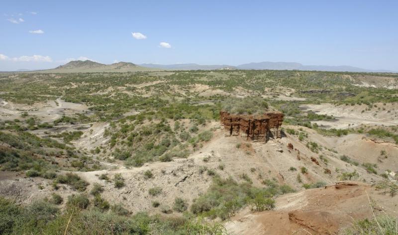
Olduvai Gorge & Laetoli
"Cradle of Mankind"
Over the last thirty years or so, it has become increasingly apparent that Africa is probably the "Cradle of Mankind" From Africa they spread out to populate the rest of Earth. Remains of the earliest humans were found in Oldupai Gorge.
Olduvai Gorge is a site in Tanzania that holds the earliest evidence of the existence of human ancestors. Paleoanthropologists have found hundreds of fossilized bones and stone tools in the area dating back millions of years, leading them to conclude that humans evolved in Africa.
Olduvai is a misspelling of Oldupai, a Maasai word for a wild sisal plant that grows in the area. The gorge is located in the Great Rift Valley, between the Ngorongoro Crater and the Serengeti National Park. It is 30 miles from Laetoli, another fossil-rich area. Olduvai Gorge was formed about 30,000 years ago, the result of aggressive geological activity and streams.
The steep ravine is about 30 miles (48.2 km) long and 295 feet (89.9 meters) deep, not quite large enough to be classified as a canyon. A river cuts through several layers to form four individual beds, with the oldest estimated at about 2 million years old.
At Laetoli, west of Ngorongoro Crater, hominid footprints are preserved in volcanic rock 3.6 millions years old and represent some of the earliest signs of mankind in the world. Three separate tracks of a small-brained upright walking early hominid. Australopithecus afarensis, a creature about 1.2 to 1.4 meters high, were found. Imprints of these are displayed in the Oldupai museum.
More advanced descendants of Laetoli’s hominids were found further north, buried in the layers of the 100 meters deep Oldupai Gorge. Excavations, mainly by the archaeologist Louis and Mary Leakey, yielded four different kinds of hominid, showing a gradual increases in brain size and in the complexity of their stone tools. The first skull of Zinjanthropus, commonly known as ‘Nutcracker Man’ who lived about 1.75 millions years ago, was found here. The most important find include Home habilis, Zinjathropus and the Laetoli footprints.
-
Archaeological site
-
Rock Formation
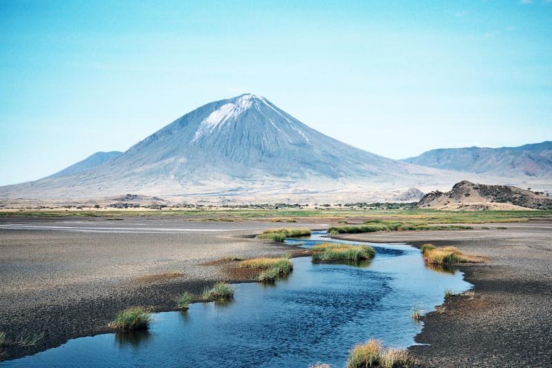
Mount Ol doinyo Lengai
"The Mountain of God"
"Oldoinyo Lengai" means “The Mountain of God” in the Maasai language. The summit of this strato-volcano is 2962 metres above sea level, and affords direct views into the caldera of Tanzania’s only officially-certified active volcano, and the world’s only carbonatite volcano; records of eruptions have been maintained since 1883, the largest of which deposited ash 100 kilometres away in Loliondo on the Kenyan border to the north west.
It is located in northern Tanzania lying just south of Lake Natron in the Rift Valley, in the heart of Maasai country, and locally regarded as a sacred mountain. Looking north from it’s summit crater, the hot barren salt flats of Lake Natron stretch into the distance. To the south stretch the crater Highlands and the Ngorongoro Game Reserve. The eastern horizons dominated by Kilimanjaro and to the west the forested escarpments and hills comprising the western slopes of the Rift Valley. Every seven years Lengai erupts and plumes of smoke billow out of the crater.
It is possible to walk across the crater floor. The ascent of Oldoinyo Lengai is demanding on account of the day time heat, lack of water, steep and unsuitable slopes of ash and crumbly rocks and considerable height gain. Normally you can start ascending to summit early in the morning and reach to summit at sunrise. Short and a warm jacket are suitable for ascent, also long trousers are good as the summit before dawn can be cold. Access route from the North West allows an early descent to be made from the summit in the morning shadow.
Standing at 2,878 meters above the Soda Ash Lake Natron, Mountain of GOD as famous to the Maasai community that inhabit the area, Mountain Ol’doinyo Lengai is situated in the Ngorongoro highlands and the African Rift valley about 120 kilometers Northwest of Arusha, Tanzania.
Since the past ancestors the Holly Lengai has been used by Maasai for their prayer to their GOD known as NGAI. Ol’doinyo Lengai is the only active volcano in the world that erupt natrocarbonatite lava which is cooler than other lavas about (510 degrees C) compare to the temperatures of basaltic lavas (1,100 degrees C) with less silicon.
The Mountain frequently does minor eruptions and form cone like structures to its crater base. While on the summit of Mountain Ol’doinyo Lengai one can sight clearly .the Soda Lake Natron which accommodates and consist of good nesting sites for different bird species especially the Flamingos, pelicans and geese more than 350 different types are recorded to date.
Unlike others two highest Mountains, Lengai takes about six to seven hours to the summit crater. Also the Mountain is an ideal place for a working safari escort by the Maasai guides with weapons tourist can sight wild animals like olive baboon, velvet, monitor lizard, hyenas, lion, leopard, jackal, Grant’s gazelle, impala and zebra.
The nearby are the Maasai BOMAS that gives you a chance to interact with the indigenous learn their cultures, taboos and traditional.
-
Mountain
-
Mountain Climbing
-
Rock Formation
-
Volcano
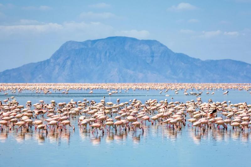
Lake Natron
Lake Natron
A soda lake at the base of the active Ol Donyo Lengai volcano, the area around Lake Natron is often described as having a desolate and almost lunar beauty. Lake Natron is found in the northern part of Tanzania. Nearest towns to Lake Natron are Arusha in Tanzania and Magadi in Kenya. It is the most important breeding site for Lesser Flamingos in the world.
East Africa has 1.5-2.5 million Lesser Flamingos, representing three-quarters of the world population and most of them are hatched at Lake Natron. Food is plentiful, nesting sites abound – and above all, the lake is isolated and undisturbed. The lake and its ecosystem provides a source of livelihoods to the local communities.
High levels of evaporation have left behind natron (sodium carbonate decahydrate) and trona (sodium sesquicarbonate dihydrate). The alkalinity of the lake can reach a pH of greater than 12. The surrounding bedrock is composed of alkaline, sodium-dominated trachyte lavas that were laid down during the Pleistocene period. The lavas have significant amounts of carbonate but very low calcium and magnesium levels. This has allowed the lake to concentrate into a caustic alkaline brine
Walks around the lake and to the streams and waterfalls along the nearby escarpment make for a fantastic adventure off the beaten track.
There are a number of campgrounds near the lake, which is also the base for climbing Ol Doinyo Lengai.
-
Lake or River
-
Lake or River