- Home
- Attractions
- All Attractions
- ATTRACTIONS PROFILES
Lake Eyasi
Lake Eyasi is a seasonal shallow endorheic salt lake on the floor of the Great Rift Valley at the base of the Serengeti Plateau, just south of the Serengeti National Park and immediately southwest of the Ngorongoro Crater in the Crater Highlands of Tanzania. The lake is elongated, orientated southwest to northeast, and lies in the Eyasi-Wembere branch of the Great Rift Valley
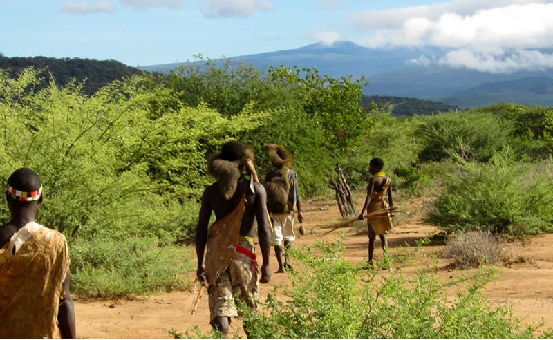
The Hadzabe bushmen live in this region, as do the Datoga and Mbulu tribes. A visit with the bushmen is worthwhile and they will graciously show you where and how they live and hunt. They subsist entirely off the bush and by bow hunting. Everything they use is made from local materials, including their bows which are strung with giraffe tendon and their arrows which are coated in lethal poison. Their language resembles that of Kalahari bushmen tribe (who were featured in the 1980 film ‘The Gods Must Be Crazy’) with clicking noises used.
The Datoga and Mbulu people are pastoralists, like the Masai people.
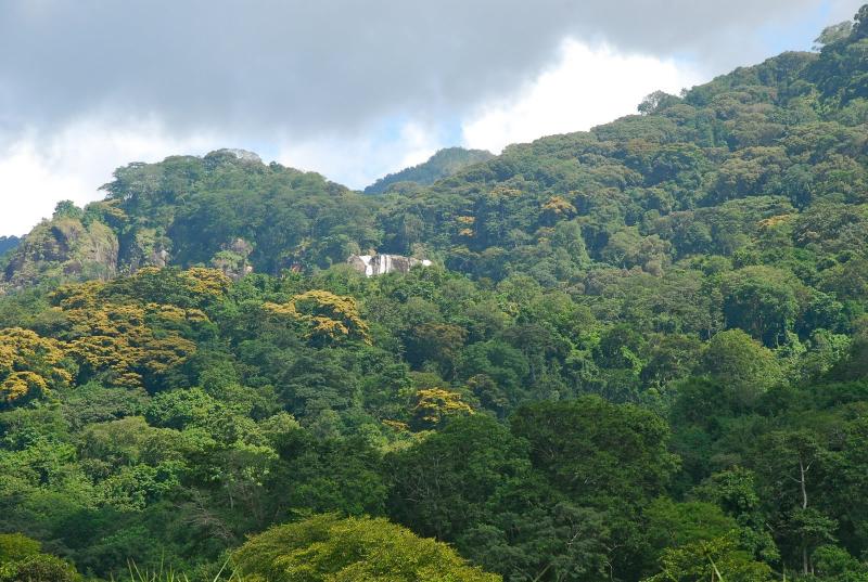
The scenery of Lake Eyasi differs dramatically to that of the surrounding areas. Compared to the Serengeti and Ngorongoro Highlands this area seems downright tropical. Palm trees border the lake and make homes for birds such as Fischer’s lovebird. Other trees in this area include the umbrella thorn acacia and sand paper bush. The weather is nearly always very hot and intense, as the lake is located in floor of the Rift Valley, the oldest rift in the world. The rift is thought to have opened over 65 million years ago, shortly after dinosaurs became extinct. To view Lake Eyasi on our Tanzania map please click here.
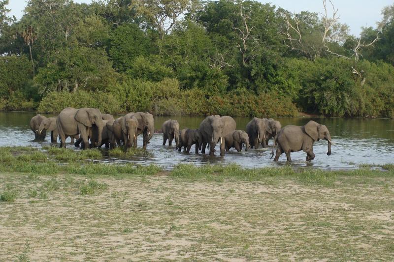
Lake Eyasi’s water levels vary greatly between the rainy and dry seasons. During the dry season the lake is virtually nonexistent and animals are forced to share what water is left, which makes for easier wildlife viewing. The lake can get quite deep during the rainy season and it attracts hippos who like to cool off in its brackish waters.
Bird lovers will be in paradise here, as the lake attracts vast numbers of birds of all sizes and colors. Some main birds to be found here include: Africa spoonbill, flamingos, gray headed gulls, great white pelicans, pied avocet and yellow-billed storks. The main fish found in the lake are catfish and lungfish.
Lake eysai palmtrees sunsetThis region is particularly suited for exploring on foot, and day or half day hikes are highly recommended. It is also possible to go on a hunting trip with the Hadzabe or to visit the other tribes. Almost any time of year is a good time to visit Lake Eyasi with only April and May being questionable as they are when the long rains occur.
-
Lake or River
-
Lake or River
Lake Chala
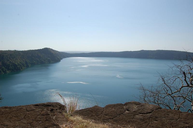
Lake Chala is a unique caldera lake, and is thought to be the deepest inland body of water in Africa. This lake is fed by underground springs from Mt. Kilimanjaro.
The lake has a great diversity of life. From lush lake shore forest to stunning volcanic savannah; from river beds marvelously carved through ancient rock, to thick bush or open ‘mbuga’. Walking at Lake Chala is a magical experience that will put you back in touch with nature.
The lake is fed by groundwater flows, which come from Mount Kilimanjaro, fed and drained underground with a rate of about 10 million m³ / year. Depending on the time of year, it ranges in colour from deep blue to turquoise and green, it is surrounded by a 100 metres high crater rim.
Chala has a huge variety of amazing trees, grasses and plants; some are unique to the area. According to the time of year there are hundreds of species of butterflies and birds, including spectacular birds of prey. The African Fish Eagle, with its haunting techniques, Verreaux’s Eagle, Augur Buzzards and many other species of birds can be seen around the crater walls. Wild mammals do vary including Blue Monkeys, Colobus Monkeys, baboons, dik-dik, kudu and elephant. Chala is an untouched part of a truly ancient land and a must visit place.
Activities at this lake: walking safaris, canoeing, swimming and fishing.
-
Lake or River
-
Lake or River
Pare Mountains
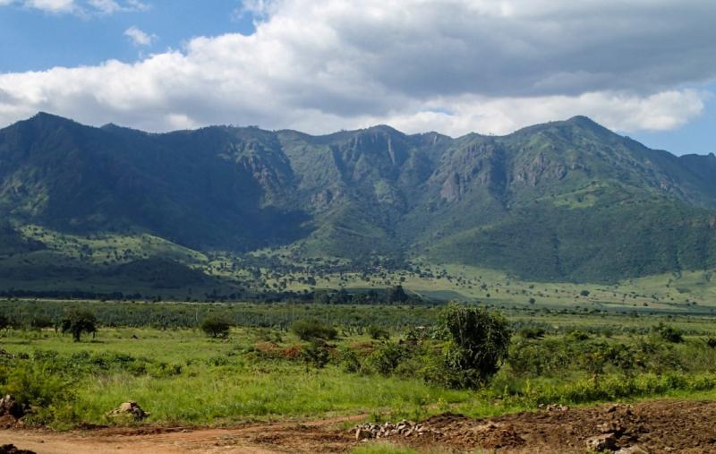
Part of the Eastern Arc range in north-eastern Tanzania, the remote Pare Mountains are extremely rewarding to the avid trekker searching for hiking trails off the beaten path. Home to the Pare tribe, agriculturalists and pastoralists who have largely retained their traditional way of life, a hike through the Pare Mountains takes visitors through local villages and beautiful forests as well as it offers the chance to explore a less visited part of the country.
The Pare Mountains are part of the Eastern Arc Mountains, an isolated range of ancient massifs that stretch form the Taita Hills in southeastern Kenya into Tanzania, where the range includes the Pare Mountains, East and West Usambara and the Ulugurus near Morogoro and the Udzungwa Mountains. The steep crystalline ridges and peaks of the Eastern Arc area are much older and a geologically separate formation from Mount Kilimanjaro and Mount Meru. The current ranges began to take shape some 100 million years ago, and attained their present form at the start of the Miocene Epoch, 25 million years ago.
The southern Pare Mountains are situated in Kilimanjaro Region, about 150 kilometre south of Moshi. From the surrounding plains, the mountains look like a barren and deserted area, but when you start climbing the slopes, one of Africa’s most special landscapes is revealed for your eyes. Between huge desolate rocks lie small green river valleys where farmers have built impressive stone terraces. On top of the mountains is the Chome forest reserve, a dense tropical forest with many rare trees and plants. The forest offers an oasis of rest, beauty and fresh air. Visitors can easily walk a day through the forest without meeting anyone. The surrounding villages are among the most isolated places in Northern Tanzania and the local people have kept their traditional Pare culture throughout history. Narrow footpaths wind through the mountains from one village to another.
Southern Pare Mountains Tours Includes:
- A walk through the Chome forest reserve, a tropical forest of over 100 square kilometre.
- A climb to Shengena Peak, the highest point in the Pare and Usambara mountains
- A view into the Pare culture (old stories, traditional dances)
- A visit to several development projects in our villages (irrigation, soil conservation, afforestation)
A stay in the Southern Pare Mountains can perfectly be combined with a visit to the neighbouring Mkomazi Game Reserve, where game drives and walking safaris are possible.
-
Forest
-
Mountain
-
Mountain Climbing
Lake Jipe
Lake Jipe is a small, shallow lake (area 28 sq. km and average depth less than 3 m), lying astride the Kenya-Tanzania border, just to the east of the northern Pare Mountains of Tanzania (Mwanga district, in the Kilimanjaro region).
It is 12 km long and 2.5 km wide, 12 square km belong to Tanzania and 14 square km to Kenya. Tsavo West National Park of Kenya borders the southern portion of the lake while Mt Kilimanjaro dominates the horizon some distance to the northwest.
Lake Jipe receives its main inflow from Mt Kilimanjaro in Tanzania via River Lumi passing through Kenya. The other main inflow is via River Muvulani from the Pare Mountains. Several temporary streams, mainly from the Pare Mountains, also drain into Lake Jipe. The lake has one outflow, the River Ruvu, located in Tanzania to the south of River Lumi, the main inflow.
Jipe is a shallow backwater of the Lumi river, which afterwards becomes the Ruvu River, and enters in the Nyumba ya Mungu Reservoir. After joining there with the Kikuletwa the stream flows as Pangani River in the Indian Ocean at Pangani.
As for wildlife, Lake Jipe not only offers an abundance of hippo and crocodile but there is also a small herd of zebras, To the northern end of the lake are also a few tiny villages whose inhabitants make a living from fishing.
-
Lake or River
-
Lake or River
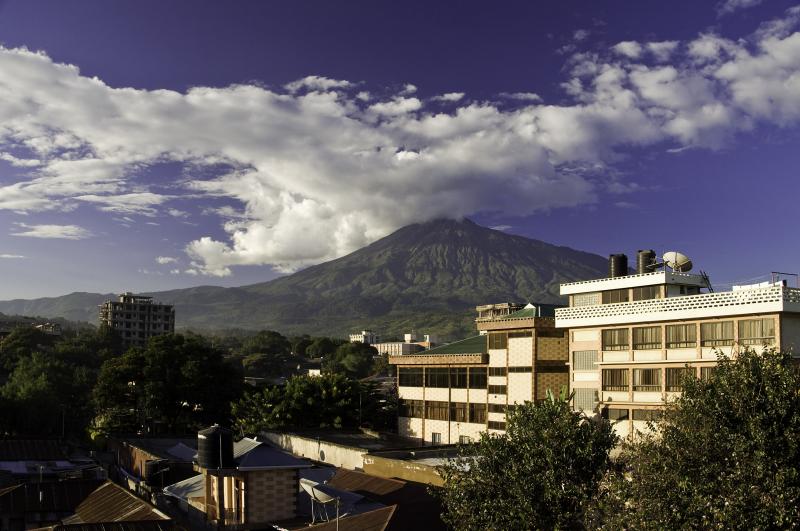
Arusha City
Located in the northern highlands of Tanzania, beneath the twin peaks of Mt. Meru and Mount Kilimanjaro, Arusha is the safari capital of the country. Guests embarking on the popular northern safari circuit all stop in the ‘Geneva of Africa’ to prepare for their journeys into the African bush.
From is two-lane streets, the dramatic crater of Mt. Meru stands over the town like a majestic sentinel, it’s crater strewn with thick clouds, it’s slopes dark with verdant forest. Arusha’s ideal location near the major national parks and it’s highland setting make it a peaceful idyll of relaxation before the start of an exciting journey.
Built by the Germans as a centre of colonial administration administration in the early 20th century, Arusha was a sleepy town with a garrison stationed at the old boma and a few shops around a grassy roundabout. From its backwater status amidst the farmlands and plantations of northern Tanzania, today Arusha is one of the country’s most prosperous towns.
Arusha is a major international diplomatic hub. The city hosts and is regarded as the de facto capital of the East African Community. Since 1994, the city has also hosted the International Criminal Tribunal for Rwanda. It is a multicultural city with a majority Tanzanian population of mixed backgrounds: indigenous Bantu, Arab-Tanzanian and Indian-Tanzanian population, plus small White European and white American minority population. Religions of the Arushan population are Christian, Jewish, Muslim, and Hindu.
The current site of Arusha was first settled in the 1830s by the agro-pastoral Arusha Maasai from the Arusha Chini community, south of Mount Kilimanjaro. They traded grains, honey, beer, and tobacco with the pastoral Kisongo Maasai in exchange for livestock, milk, meat, and skins. Demand for Arusha’s foodstuffs increased substantially during the 1860s when the Pangani Valley trade route was extended through Old Moshi, Arusha, and ultimately to western Kenya. Although it was not yet a town, it was a regional centre and had a number of urban features.
Despite its proximity to the equator, Arusha’s elevation of 1,400 metres (4,600 ft) on the southern slopes of Mount Meru keeps temperatures relatively low and alleviates humidity. Cool dry air is prevalent for much of the year. The temperature ranges between 13 and 30 degrees Celsius with an average around 25 degrees. It has distinct wet and dry seasons, and experiences an eastern prevailing wind from the Indian Ocean, a couple of hundred miles east.
-
Birding Site
-
Community Tourism
-
Cultural Centre
-
Cultural Museum
-
Historical Museum
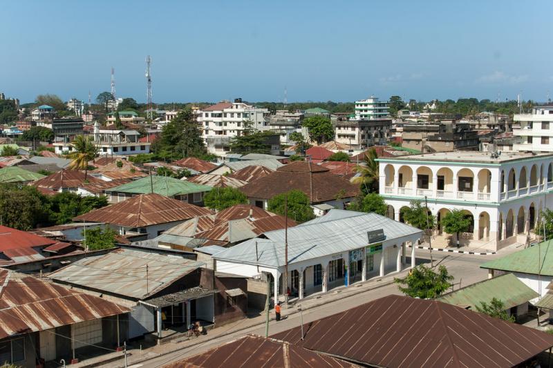
Tanga City
Tanga was once another stopping point, in competition with Pangani and Bagamoyo, for caravans on their way to the hinterland of Central Africa searching for ivory and slaves. The Germans also made it a centre of colonial administration during their occupation in the early 20th century. Evidence of German’s presence can be found in Tanga’s architecture today, but only few landmarks and historical buildings have remained in the area. Tanga’s port, however, provides a main link between northern Tanzania and the Indian Ocean.
For the discerning tourist and intrepid traveler, Tanga region is a stunning diverse destination. It undoubtedly has a lot to offer and is a surprisingly safe and friendly place to travel, filled with an incredible mixture of different cultures and some of the best places to visit.
This is evident in many aspects of life, particularly visible in the region’s magnificent landscape, unique culture and friendly people - making it as one of the preferred destinations for adventurous travellers. Thousands of kilometres of the long Indian Ocean coastline with its sheltered bays and lagoons, and the lush mangrove forests, pristine semi-arid forests help to shape the identity of Tanga.
The first thing that visitors notice on their arrival is the state of relaxation and prosperity that is palpable, and it is good to bask in the sunlit narrow streets of Tanga with most of the city roads done to perfection. The experience an exhilarating stretch of tarmac roads in Tanga is bound to satisfy a desire of any traveler.
Self-drive holidays in Tanga are great - the roads are well signposted and easily navigated - but don’t underestimate the value of a good guide who will show you parts of the area you may not have otherwise explored.
Location
Tanga is situated on the Tanzanian northern coast close to the Kenyan border.
Access
It has road connections with Arusha, Moshi, Mombasa, Nairobi and Dar es Salaam. Tanga has a small airport as well as airstrips at Ushongo (Pangani) and Saadani national park. Boat services are available to Pangani, Pemba and Zanzibar.
Accommodation
Tanga has a huge pack of facilities in the city centre and along the beach areas. The popular for visitors include: Tanga Beach Resort, Mkonge Hotel, Mtendele hotel, Inn by the Sea, Regal Naivera hotel, Nyinda Classic hotels, New Dolphin hotel, Nyumbani hotels and resorts, CBA hotel, Palm Court Hotel and more. Rate’s ranges between US$ 20 to US$ 150 per night.
Tanga has several popular restaurant featuring coastal food menus including local foods such as Rusha Roho restaurant, Raskazone swimming Club, Tanga bathing club, Tanga Yatch Club and Jet Bar and Restaurant.
Other Services:
Tanga has a few branches of financial institutions such as NMB, NBC, CRDB, Exim, Barclays and Post Bank. Health services are available at the Bombo regional hospital as well as several private hospitals. The regional police post is stationed in town.
Amani Nature Reserve
Amani Nature Reserve (ANR), located in the East Usambara Mountains, is a paradise of nature with unique flora and fauna. It has been termed as the “Last Paradise.” The flora species composition is diverse; trees of over 60 meters tall exist throughout the reserve while below, many different types of plant species are supported by them.
Amani situated in the pockets in the East Usambara Mountains, is part of the huge natural entity that makes up the Eastern Arc Mountains. It was Gazetted in 1997 with the main objective to involve the local community to take part in the management of the reserve and forest conservation to increase income generating opportunities.
The ANR has a total area of 8380 hectares divided into ecological zones that is home to a collection of medicinal
-
Beach
-
Community Tourism
-
Coral Reef
-
Cultural Centre
-
Cultural Museum
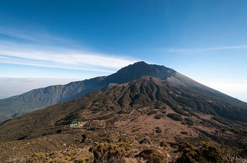
Mount Meru
Mount Meru is a dormant stratovolcano located 70 kilometres (43 mi) west of Mount Kilimanjaro in the country of Tanzania. At a height of 4,562.13 metres (14,968 ft), it is visible from Mount Kilimanjaro on a clear day,and is the fifth-highest mountain in Africa, dependent on definition.
Mount Meru is located just north of the city of Arusha, in the Arusha Region of Tanzania. It is the second-highest mountain in Tanzania, after Mount Kilimanjaro. The Momella route – which starts at Momella gate, on the eastern side of the mountain – is used to climb Mount Meru. Much of its bulk was lost about 8,000 years ago due to an eastward volcanic blast, similar to the 1980 eruption of Mount St. Helens in the U.S. state of Washington. Mount Meru most recently had a minor eruption in 1910. The several small cones and craters seen in the vicinity probably reflect numerous episodes of volcanic activity. Mount Meru's caldera is 2.2 miles (3.5 km) wide
Mount Meru is the topographic centerpiece of Arusha National Park. Its fertile slopes rise above the surrounding savanna and support a forest that hosts diverse wildlife, including nearly 400 species of birds, and also monkeys and leopards.
-
Mountain
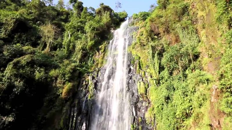
Materuni and Kuringe Waterfalls
This very impressive Waterfall is one of the tallest in the area, spewing crystal clear glacier water 70m into its basin. The beautiful path leading to Materuni Waterfall is located 2500m above sea level
It traverses thru valleys and hills covered by tropical rainforest, past coffee, banana and avocado “shambas”, the Kiswahili word for farms. On a clear day great views of Kibo and Moshi town can be seen. The hike to the base of the Waterfall can be demanding and hiking boots are recommended. As this trip is so close to Moshi town it is ideal for those people with limited time but who would still like to see some of the nature and beauty that this region of Tanzania has to offer.
Materuni is one of the few villages of wonder in Northern Tanzania sitting at the foot of Mount Kilimanjaro. The village is blessed with full of all the beauty worth much visiting for holiday, week-end outing or vacation. While in the village, scenic view of Moshi Town and Mount Kilimanjaro is astonishing. This green village with fresh air from green vegetations welcomes visitors to explore the beauty of the land and cultural heritage of the Chagga people.
A cultural experience such as banana beer brewed or coffee roasted the traditional way can be added to your hike
-
Natural Springs
-
Rock Formation
-
Waterfalls
Udzungwa National Park
Udzungwa is the largest and with most biodiversity and a chain of a dozen large forest-swathed mountains that rise majestically from the flat coastal scrub of eastern Tanzania. Known collectively as the Eastern Arc Mountains, this archipelago of isolated massifs has also been dubbed as the African Galapagos for its treasure-trove of endemic plants and animals, most familiarly being the delicate African violet.
Brooding and primeval, the forests of Udzungwa seem positively enchanted: a verdant refuge of sunshine-dappled glades enclosed by 30-metre (100 foot) high trees, their buttresses layered with fungi, lichens, mosses and ferns.
Udzungwa alone among the ancient ranges of the Eastern Arc has been accorded the national park status. It is also unique within Tanzania in that its closed-canopy forest spans altitudes of 250 metres (820 feet) to above 2,000 metres (6,560 ft) without interruption.
Although not a conventional game viewing destination, Udzungwa is a magnet for hikers. An excellent network of forest trails includes the popular half-day ramble to Sanje Waterfall, which plunges 170 metres (550 feet) through a misty spray into the forested valley below.
The more challenging two-night Mwanihana Trail leads to the high plateau, with its panoramic views over the surrounding sugar plantations, before ascending to Mwanihana peak, the second-highest point in the range.
Ornithologists are attracted to Udzungwa for an avian wealth embracing more than 400 species, from the lovely and readily-located green-headed oriole to more than a dozen secretive Eastern Arc endemics.
Four bird species are peculiar to Udzungwa, including the forest partridge, first discovered in 1991 and more closely related to an Asian genus than to any other African fowl.
Of six primate species recorded, the Iringa red colobus and Sanje Crested Mangabey both occur nowhere else in the world – the latter, remarkably, remained undetected by biologists prior to 1979.
Undoubtedly, this great forest has yet to reveal all its treasures: ongoing scientific exploration will surely add to its diverse catalogue of endemics.
Location:
Five hours (350 km/215 miles) from Dar es Salaam; 65 kms (40 miles) southwest of Mikumi.
Getting there
Drive from Dar es Salaam or Mikumi National Park.
What to do
From a two-hour hike to the waterfall as well as camping safaris.
Combine with nearby Mikumi or en route to Ruaha.
Accommodation
- Camping inside the park.
- Bring all food and supplies.
- Two modest but comfortable lodges with en-suite rooms within 1km of the park entrance.
-
National Park
Selous Game Reserve
Selous Game Reserve is Africa's largest game reserve and one of favourite game viewing areas in Africa. Covering 50,000 square kilometres, is amongst the largest protected areas in Africa and is relatively undisturbed by human impact
Africa’s largest and oldest game reserve is one of its most scenic wildlife destinations; the Selous is utterly beautiful. The beauty of the park is matched by the quality of a safari here; boating, walking and fly camping compliment standard game driving in thriving wildlife areas. This is an outrageously good safari park and an essential component of any southern circuit itinerary.
The Selous is a superb safari destination for both family safaris and African honeymoons, all the better for the ease of getting there and the lack of crowds. The park has the widest diversity of safari activities in the country, offering the boating safaris as well as standard game drives, walking safaris and legendary fly camping trips.
The Northern section of Selous is home to a network of channels and lagoons that run off the Rufiji River. This lush landscape provides a water supply for the region’s game and towards the end of the dry season the concentration of animals around these water sources is phenomenal. It is here, around the river and lakes, that the majority of the camps are based; successfully relying on the animal’s need for water to provide game viewing areas. Selous is in its peak season from July through to the middle of November - this when the dry season is raging and all the game homes in on the few permanent water sources.
The sheer volume of game in the Selous is outstanding with statistics putting most parks in Africa to shame. Elephant, buffalo and lion are ‘arguably’ found in no greater numbers year round anywhere on the planet. But it is the Selous’ reputation as the last true stronghold for African wild dog that draws the enthusiasts.
-
National Reserve
Lake Nyasa / Lake Malawi
Lake Nyasa, also called Lake Malawi, lake, southernmost and third largest of the East African Rift Valley lakes of East Africa, lying in a deep trough mainly within Malawi.
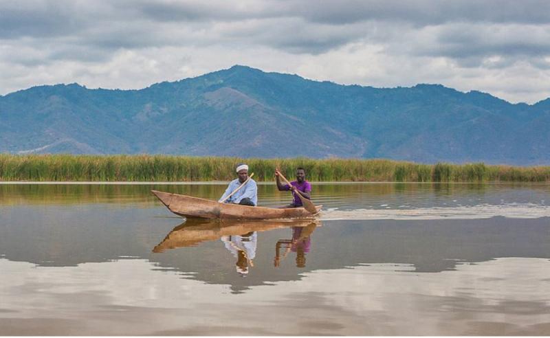
Lake Nyasa (Nyasa means “lake”) is located at the south-west of Tanzania, The lake lies in three countries’ territory; Tanzania and Malawi. However, it is bordered by three countries, Tanzania , Malawi and Mozambique. It is the third largest in Africa (after Lake Victoria and lake Tanganyika) with 550 kilometers length and 75 kilometers width, covering an area of more than 11,400 square kilometers. In some parts, the lake is as deep as 700 meters.
The Lake lies in the sided walls of mountain ranges: the forested Livingston Mountains and Nyika Plateau, which provide the magnificent view of the lake from far and the landscape for hikers and backpackers. Lake Nyasa is also among the Great Rift Valley’s lakes, which shares some of the characteristics with lake Tanganyika. The lake has a distinctive characteristic: 14 rivers pouring their waters into the lake, and only one river which flows out to the sea, River Shire.
The Lake also has a lot of names such as “Lake of stars” which is provided by the lovers who trip their and discover it one of the dreamy and romantic destination in Eastern Africa. It is situated between Malawi, Mozambique as well as Tanzania. It has so many things to offer such as numerous opportunities for water sports as well as diving. The lake is enormously rich with diverse fish species and is one of the most appealing lakes that offer unforgettable underwater views!
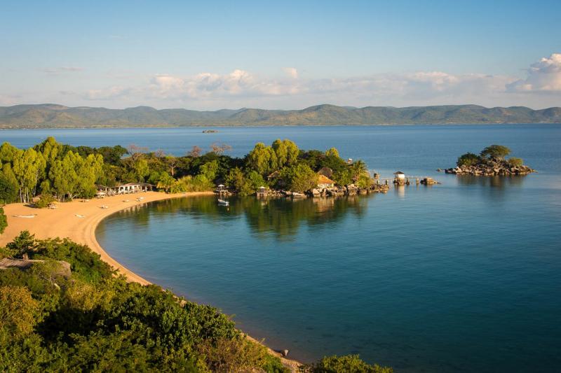
Some parts of the lake offer nice beaches and places to swim. Matema, in the northern part of the lake is considered to be the best beach for people who like to relax swim along the lake shore. In contrast to other lakes the water of lake Nyasa is bilharzias free. There are also caves and interesting waterfalls to see.
Other activities include local canoeing ride down the river, hiking on surrounding mountains.
Though Lake Nyasa does not receive many tourists, the lake is magnificently attractive and is rich in crocodiles and hippopotamus. For Fish lovers, Lake Nyasa is biologically the most diverse lake, containing approximately 30% of world’s cichlid species (colorful fish which are easily seen in the lake’s clear water)
Volume 7,775.00 km3, Surface Area 29,500.00 km2, Depth Mean depth: 264.0m Maximum depth: 706.0m
-
Boating
-
Lake or River
-
Lake or River
-
Waterfalls
.jpg)
The Dar es Salaam Marine Reserve System
The Dar es Salaam Marine Reserve System (DMRS) is a group of marine wildlife reserves in Tanzania, situated off the coast of Dar es Salaam Region. The reserve system consists of Seven (7) islands of Bongoyo, Mbudya, Pangavini, Fungu Yasini, Makatobe, Sinda and Kendwa. It provides protection for several important tropical ecosystems; coral reefs, mangroves and seagrass beds. These reserves are managed by Marine Parks and Reserves Unit (MPRU) through the Marine Parks and Reserves Act No. 29 of 1994.
Bongoyo Island Marine Reserve
Bongoyo Island lies close to Msasani Peninsula in dare s Salaam city, about 30 minute by boat ride from the city mainland. The place of departure for most visitors who wants to visit the Bongoyo Island is the ‘Slipway’mall complex on the western side of the Msasani Peninsula in Dar es Salaam.
Location: Bongoyo Island is located about 2.5km north of the Dar es Salaam city. This island is the most frequently visited islands in the city.
Accessibility:
- It is about 30 minutes ride by motorized dhow from Msasani slipway to Bongoyo Island.
- The Msasani slipway has boats, which makes go and return visits to the island 4 times a day. There are a number of visitors who arrives on the island by means of their private own boats or hired boats from beach hotels.
- 10 min by speedboat from Msasani bay.
Attractions:
- Marine species; the main coastal habitats around Bongoyo Island include sand beaches (beach I and II), coral reefs, sea grass beds, rocky shores, lagoons (shark lagoon) and algal beds.
- Plants and animals; Two species of hawksbill (eretmochely imbricata) and green turtles chilonea are reported to occur around Bongoyo and Mbudya islands
- Lagoon Cave & Sharks; Bongoyo Island is a popular destination for those looking to get away from civilization for a while. There are plenty of snorkeling opportunities in places like Shark’s Lagoon Cave that was named after young sharks that swim along the shores hunting for octopies.
- Hiking; Hiking around Bongoyo Island is also popular although many visitors like to simply sit on the beach with a good book or relax with a picnic.
Mbudya Island Marine Reserve
Mbudya Island (simply Mbudya) is an uninhabited island in Tanzania, north of the Country’s capital city, Dar es Salaam and is one of the four island of the Dar es Salaam Marine Reserve (DMRS).
The Island lies close to the beach resort and fishing Community of Kunduchi and is reachable by means of a 20 minutes motorboat ride crossing from the mainland. It is therefore a popular daytrip for both tourists and Tanzanian residents alike, serving as a location for a variety of leisure activities, including snorkeling, sunbathing and hiking. The Island offers fabulous snorkeling and diving opportunities and is a fourable day outing for visitors to the section of Tanzania coast. Mbudya Island is situated about 3km offshore, within easy reach of the hotels on the north coast of Dar es Salaam.
There are hereby sand beaches on the western and eastern sides. On the western side, it is possible to have barbecued fish with chips and drinks. There is plenty of shade under the casuarina trees.There is a washroom located near the resting beach. On the beach there are bandas where you can rest while enjoying chips with fish and soft drinks.
Mbudya has many to offer and it is such a great way to spend a weekend in Dar es Salaam, Its a home of Crabs, Snorkeling, Diving, hiking and sunbathing. The water & scenery of Mbudya were picture perfect…so relaxing and amazingly beautiful. One is able to snorkel & see some of the colorful fish hiding in the Indian Ocean coral reef.The Island is covered with dense stands of Palms and Baobabs. The rare Coconut crabs are found on the Island. To get to the Island, one of many local motorized dhow and ngalawa can be hired. The hotels like White Sands, Silver Sands, Kunduchi beach, Beach Comber and Bahari beach are able to provide more modern transport to the Island.
Pangavini Island Marine Reserve
Pangavini Island is an uninhabited island in the Zanzibar Channel in Tanzania, north of the country’s capital city, Dar es Salaam and is one of the nine islands of the Dar es Salaam Marine Reserve System . The island is small, only about 250 m long; it has a rocky coastline without beaches. Pangavini Island is an important breeding, resting and feeding site to a variety of rats, birds and reptiles . There is also an assortment of insects including butterflies.
Fungu Yasini Island Marine Reserve
Fungu Yasini Island (or simply Fungu Yasini) is an uninhabited island in Tanzania, north of the country’s capital city, Dar es Salaam and is one of the four islands of the Dar es Salaam Marine Reserve (DMRS). It is about three miles offshore in the Indian Ocean (Zanzibar Channel).
Some Tourism attractions found in Dar es salaam Marine Reserves System:
Clean and crystal water
The Dar es Salaam Marine Reserves System are unique due to their good scenic diving and snorkeling sites.
Marine Turtle
The reserves are breeding ground of the endangered turtle; the common species are green and hawksbill turtles both of them nests in the reserves.
turtle
Coconut Crab:
The rare Coconut Crab - the largest land crab on earth - is common on Mbudya Island; as its name suggests this crab feeds on coconut, and is actually able to climb coconut palms, where it is thought to pinch off coconuts with its powerful claws when coconuts are not already available on the ground.
Birds
These islands have the splendor of being the home of most of the being the home of most of the birds that hove over Dar es Salaam city during the day. The reserves save as a stopover of migratory birds during their flight from winter and it is also the nesting sanctuary of the birds.
Sea grass beds:
The lucky swimmers can also see the rare sea horse on the sprawling sea grass beds, an indicator that the reserves are pristine and virgin.
Historical Ruins:
DMRs host ruins of a German outpost and a tomb. The tombs have generated myths, and pull visitors who visit them to pay homage and make sacrifices for cleansing and fortune.
Beaches:
There are number of unspoiled beaches to explore and have fun in DMRs.
Coral Reefs:
Over 200 species of hard and soft corals are found in these reserves, these are pristine areas for snorkeling and diving. Also more than 300 species of marine fish are found in the reserves.
More Activities
- Visitors use the Dar Marine Reserve as day light resorts and camping. Facilities available on the islands include shades (bandas), information board and nature trails.
- While at the islands, visitors could be serves with bites, drinks and fresh cooked fish served by local community members who are responsible for tour guide, security and first aid.
- The community members also play a vital role of being honorary rangers for the Marine Reserves in all activities related to conservation and protection of the environment.
- Visitors wishing to visit the scenic island are encouraged to collect electronic tickets at Slip way Hotel, White sands hotel and Marine Parks and Reserves Unit HQ office before touring the island to avoid disturbances. It is illegal to visit the islands without valid ticket!
-
Beach
-
Boating
-
Community Tourism
-
Coral Reef
-
Snorkeling